Map Reader — tracing history off the page
A TimeWalk toolset for turning georeferenced historical maps into PostGIS building footprints, with SAM (Segment Anything) doing the tedious part of tracing ink. Repo: TimeWalk/Map_Reader on Gitea.
What this is
TimeWalk rebuilds historical cities (Manhattan 1776, Philadelphia 1776, Boston…)
in Unreal Engine. The geometry pipeline starts with a period map, georeferenced as a
Cloud-Optimized GeoTIFF (COG), from which we trace individual building footprints into
the timewalk PostGIS schema. Hand-tracing is accurate but slow — minutes
per building, and colonial Philadelphia alone has thousands. Map Reader collects
tooling that lets a segmentation model (Meta's SAM) do the outline work from a single
click or box prompt, while a human stays in the loop for verification.
The tool landscape
A QGIS plugin — in the official QGIS plugin repository — that runs SAM's image encoder once over a raster (offline, minutes), then gives near-instant (<1 s) interactive segmentation from point/box prompts inside QGIS, on CPU. v2 adds SAM2/SAM3 backbones. Best fit for the human-in-the-loop workflow: click a building, get a polygon, accept or fix, next. No GPU, no training data. github.com/coolzhao/Geo-SAM
ETH Zurich research fine-tuning SAM specifically for historical map feature extraction (buildings, vineyards, railways on Siegfried maps). Crucially it is prompt-free: after fine-tuning it batch-extracts a whole sheet with no human clicking — the only route here to real automation rather than acceleration. Needs a GPU and annotated tiles, both reachable (PC-5090's RTX 5090; tiles are the by-product of an interactive Geo-SAM pass). github.com/Xue-Xia/MapSAM · arXiv:2411.06971 · arXiv:2510.27547
Qiusheng Wu's MIT-licensed Python package wrapping SAM for geospatial rasters: handles georeferencing, point/box prompts, tiling, batch runs, and vectorization to GeoPackage/Shapefile; a QGIS plugin was added in 2025. This powers our scripted pilot below — fully reproducible, no GUI needed. samgeo is the backbone; Geo-SAM is the cockpit. github.com/opengeos/segment-geospatial
The closest historical precedent: NYPL auto-vectorized fire-insurance atlases into 170,000+ building footprints feeding the crowdsourced Building Inspector — same problem, same verification loop we're copying. Python-2 era and abandoned, so don't run it as-is; but its color-threshold →
gdal_polygonize approach remains a
valid no-ML baseline that can beat SAM on clean flat-color maps.
github.com/nypl-spacetime/map-vectorizerTuring Institute library for analysis of large map corpora: cuts sheets into patches and classifies them (railspace, buildings-present). No polygons, so it can't do the core job — but it answers the step-earlier question of which sheets are worth georeferencing at all (the triage failure that burned us on the 1777 Pelham Boston map). github.com/maps-as-data/MapReader
University of Minnesota pipeline that detects and recognizes text labels on historical maps at scale (applied to the David Rumsey collection). Complements footprint tracing: street, place and owner names populate attribute columns for the geometry the SAM tools produce. github.com/knowledge-computing/mapkurator-system
Ranked verdict
| rank | tool | role | needs |
|---|---|---|---|
| 1 | Geo-SAM | best immediate win — interactive tracing in QGIS, today | CPU only |
| 2 | MapSAM/MapSAM2 | path to full automation — prompt-free batch extraction | GPU + annotated tiles |
| 3 | samgeo | scriptable backbone — reproducible runs, evaluation, glue | CPU only |
| — | NYPL vectorizer | no-ML baseline worth comparing against; don't run as-is | legacy |
| — | MapReader | corpus triage: which sheets are worth the effort | — |
| — | mapKurator | attribute enrichment from map labels | — |
Recommended sequence: run the interactive Geo-SAM pass now to get real footprints into PostGIS; keep every accepted polygon as a training pair; once enough accumulate, fine-tune MapSAM on PC-5090's RTX 5090 with those pairs and move to prompt-free batch extraction; keep samgeo as the scripted layer that runs and scores both.
Pilot: 1762 Clarkson & Biddle, Philadelphia
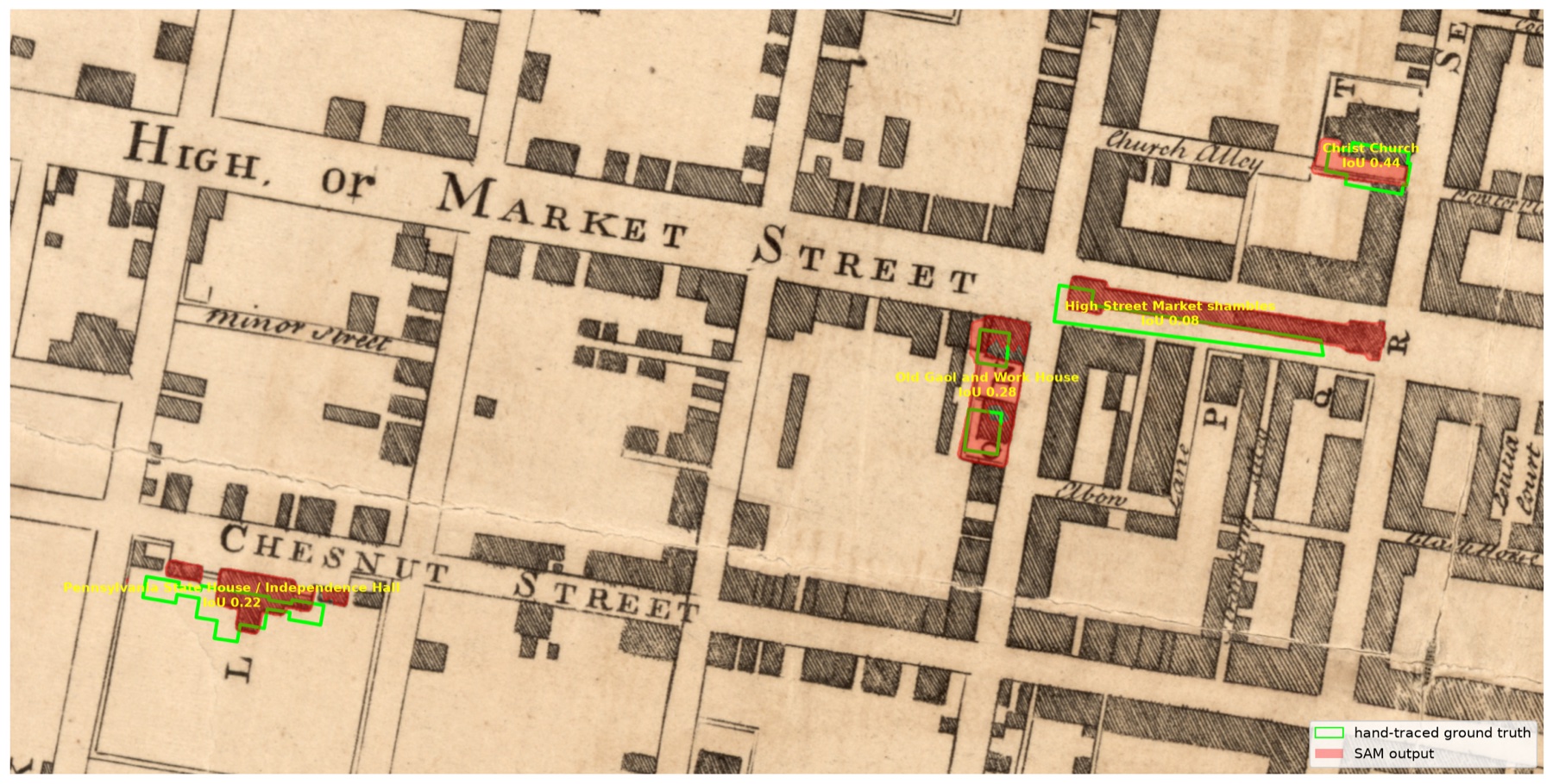
We ran the scripted samgeo flow against a map we had already hand-traced, so we
could score the machine against human ground truth. Source raster:
tw_1762_philadelphia_map_clarkson_biddle_cog.tif (EPSG:3857, 0.41 m/px,
our best-georeferenced Philadelphia sheet — median residual ~6 m). Ground truth:
hand-traced landmark parcels in PostGIS
(timewalk."1776_philadelphia_parcels_landmarks"). Four landmarks that
existed in 1762 were prompted with a padded box each (simulating a user dragging a
rough box), on a 2298×1148 px crop of the city core, SAM ViT-B on CPU (Mac mini).
| id | building | IoU | precision | recall | predict |
|---|---|---|---|---|---|
| 1 | Pennsylvania State House / Independence Hall | 0.220 | 0.349 | 0.374 | 0.08 s |
| 2 | Christ Church | 0.442 | 0.721 | 0.532 | 0.07 s |
| 13 | High Street Market shambles | 0.081 | 0.127 | 0.181 | 0.06 s |
| 19 | Old Gaol and Work House (Old Stone Prison) | 0.281 | 0.302 | 0.808 | 0.06 s |
| mean | 0.256 | ||||
Timing on CPU: one-time image encode ~5 s per window, then 0.06–0.09 s per building prompt. (Box-only prompts scored mean IoU 0.186; adding the centroid point raised it to 0.256.)
Honest verdict
Mean IoU 0.256 is too low for unattended auto-tracing, and the reasons are instructive: SAM tends to grab a whole hatched block or street-length strip from one prompt; thin geometries (the market shambles is ~10 px wide) lose most of their IoU to a few pixels of lateral offset; and for surviving buildings our ground truth is the modern OSM footprint by policy, which intentionally disagrees with the period ink SAM is tracing. The ~6 m median georeferencing residual (~15 px) shifts everything a little more.
The speed result is the real finding: after a one-time ~5 s encode, prompts return in under a tenth of a second on a CPU. That makes the interactive QGIS Geo-SAM flow genuinely viable — click a building, get a draft polygon instantly, fix its corners, accept. SAM is a tracing accelerant, not a tracer. Upgrade paths: the larger ViT-H checkpoint, negative points on neighboring buildings to split hatch blocks, and MapSAM-style fine-tuning on our own hand-traced pairs.
How to use it
A. Interactive tracing in QGIS (Geo-SAM)
- Install the Geo-SAM plugin
(QGIS ≥ 3.30; install
torch+torchgeointo QGIS's Python first, then copy the plugin into your QGIS plugins folder and enable it). - Load the COG in QGIS, then run Geo-SAM Image Encoder on the map (or a clipped working area). This is the slow step — it saves encoder features to disk.
- Open the Geo-SAM Segmentation panel, point it at the saved features, and trace: left-click inside a building (foreground point), right-click to exclude (background point), or drag a box. Press S to save each polygon.
- Save the shapefile/GeoPackage, clean geometry (see policy below), and load to PostGIS.
B. Scripted batch flow (samgeo) — what the pilot ran
# 1. environment (Python ≥3.10)
python3 -m venv env
env/bin/pip install segment-geospatial torch torchvision

# 2. crop a working window from the COG (bounds in EPSG:3857)
gdal_translate -projwin XMIN YMAX XMAX YMIN \
  tw_1762_philadelphia_map_clarkson_biddle_cog.tif crop.tif
# (or rasterio: see pilot/crop.py — useful when brew gdal is broken)

# 3. segment with box/point prompts and vectorize
#    (full script: pilot/run_sam.py)
python - <<'EOF'
from samgeo import SamGeo
sam = SamGeo(model_type="vit_b", automatic=False)   # checkpoint auto-downloads
sam.set_image("crop.tif")                            # one-time encode
masks, scores, _ = sam.predictor.predict(box=box_px, multimask_output=False)
# vectorize mask -> polygons with rasterio.features.shapes (georeferenced)
EOF

# 4. score against ground truth / inspect
python pilot/compare_iou.py
C. Load results to PostGIS
ogr2ogr -f PostgreSQL \
  PG:"host=db.<project>.supabase.co port=5432 dbname=postgres user=postgres sslmode=require" \
  pilot/results/sam_output.gpkg sam_footprints \
  -nln timewalk.sam_footprint_candidates \
  -nlt MULTIPOLYGON -t_srs EPSG:3857 -lco GEOMETRY_NAME=geom
Load into a candidates table, review in QGIS against the raster, then merge approved rows into the era parcel table.
Geometry policy (Sunil, 2026-08-19)
Demolished buildings: trace the drawn ink on the aligned period raster (full plot for burial grounds/yards). Surviving buildings: use the true modern OSM footprint, even where the period ink disagrees — plate warp and schematic drawing make the ink less trustworthy than the standing building.
Georeferencing standard for all new maps: dense (30+) label-verified GCPs, TPS warp, OSM road-overlay verification.